
The rising risk of coastal driving
Driving on the sand is one of the best ways to see the coast, but the ground is shifting. Frequent storms and faster erosion mean the tracks we used last year might not exist today. It is no longer a predictable weekend activity.
The National Park Service has documented a clear increase in incidents related to beach driving, from vehicles getting stuck to more serious situations involving injuries and rescues. These aren’t simply inconveniences; they represent real danger. Shifting shorelines mean that familiar routes can disappear overnight, and what was once firm sand can quickly become deceptively soft. The popularity of beach driving also contributes to congestion and increased risk of accidents.
By 2026, most popular beaches will have new warning systems and tighter rules. These updates help, but safety still depends on your own preparation. You need to know which zones are closing and how the new alerts work before you head out.
Five dangerous beaches to watch in 2026
Certain coastal areas are experiencing a more rapid increase in hazards than others. Here are five locations where beach drivers need to be particularly cautious in 2026, based on recent reports from the NPS and Coast Buddy.
Cape Lookout National Seashore, North Carolina: This area is notorious for its ever-changing sandbars and strong currents. The barrier islands are incredibly dynamic; a route that's passable one day could be completely blocked the next. The NPS specifically warns against underestimating the power of the ocean here. Driving near the high tide line is especially dangerous, and attempting to traverse deep tidal flats is a recipe for disaster. Portsmouth Island, within Cape Lookout, is particularly vulnerable.
Outer Banks, North Carolina: The Outer Banks are increasingly susceptible to storm surge and erosion. Recent nor’easters have dramatically reshaped the coastline, creating new inlets and exposing previously stable dunes. Beaches like Corolla and Hatteras Island are seeing increased washouts and soft sand conditions. The risk of being stranded during a high tide event is significant. Specifically, the area around Oregon Inlet is prone to rapid changes.
Assateague Island National Seashore, Maryland/Virginia: Famous for its wild horses, Assateague also presents significant beach driving challenges. The island is narrow and low-lying, making it vulnerable to flooding and overwash. Soft sand and frequent tidal changes are common. Driving north of the Maryland Inlet is known for particularly challenging conditions. The presence of wildlife adds another layer of complexity, as drivers need to be constantly aware of horses crossing the road.
Padre Island National Seashore, Texas: While generally more stable than the Atlantic coast, Padre Island is still susceptible to erosion and strong currents. The southern portion of the island, near the Mansfield Cut, is particularly prone to soft sand and unpredictable tides. The long, flat beaches can also create a false sense of security, leading drivers to overestimate their vehicle’s capabilities. Malaquite Beach, a popular access point, has seen increased erosion in recent years.
Oregon Coast, Oregon: The Oregon Coast presents unique challenges due to its rocky terrain and powerful waves. While not all beaches allow driving, those that do – like sections of Florence and Coos Bay – require extreme caution. Log debris washed ashore is a common hazard, and the unpredictable nature of the Pacific Ocean demands constant vigilance. The combination of steep beaches and strong currents makes recovery operations particularly difficult.
How the new warning systems work
Responding to the increased risks, several new warning systems are coming online in 2026. The specifics vary by location, but the overall trend is toward more real-time information and improved communication with drivers. It’s crucial to understand what’s available and how to utilize these resources.
We're seeing a move towards dynamic signage that displays current tide levels, sand conditions, and potential hazards. These signs are often solar-powered and linked to remote monitoring systems. Several coastal communities are also developing mobile apps that provide real-time updates on beach conditions, including alerts about rip currents and approaching storms. Coast Buddy is tracking these changes closely and will be providing a comprehensive guide in the coming months.
Drones are now used to spot soft sand and debris from above. This data feeds directly into local apps and digital signs. The range of these drone patrols varies by county, but they provide a much faster look at hazards than a physical ranger patrol.
Vehicle Prep: Beyond Tire Pressure
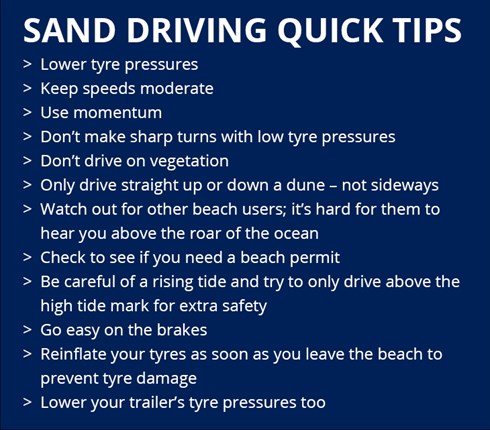
Lowering your tire pressure is a standard recommendation for beach driving, and it's important. But proper vehicle preparation goes far beyond that. Before you even think about hitting the sand, you need to ensure your vehicle is in top condition.
Check all fluid levels – oil, coolant, brake fluid, and transmission fluid. Make sure your 4WD system is functioning correctly. Test it out before you get to the beach. A faulty 4WD system can leave you stranded quickly. Inspect your tires for any signs of damage or wear. Consider carrying a portable air compressor to re-inflate your tires after leaving the beach.
A well-stocked emergency kit is essential. This should include a shovel, a tow strap (rated for your vehicle’s weight), a first-aid kit, a flashlight, extra food and water, and a blanket. Don't forget a communication device, such as a satellite phone or a two-way radio, especially if you'll be driving in areas with limited cell service. Having the right tools and supplies can make all the difference in a difficult situation.
Reading the Beach: Spotting Hidden Dangers
Knowing how to read the beach is just as important as having the right vehicle and equipment. Pay attention to the wet/dry sand line – this indicates the high tide mark. Never drive beyond this line, as you risk getting stuck when the tide comes in. The NPS offers particularly good advice on this for Cape Lookout.
Learn to recognize rip currents. These powerful currents can pull even strong swimmers out to sea. Look for channels of choppy, discolored water, or areas where waves are breaking differently than the surrounding waves. If you get caught in a rip current, don’t fight it; swim parallel to the shore until you’re out of the current, then swim to shore. Understanding wave patterns is also crucial. Larger waves can quickly wash over the beach, potentially damaging your vehicle.
Be aware of debris hidden beneath the sand. Driftwood, rocks, and other objects can cause damage to your tires and undercarriage. Avoid driving near dunes, as they are fragile ecosystems. Respect wildlife and maintain a safe distance from any animals you encounter. Remember that driving on the beach is a privilege, not a right, and it comes with a responsibility to protect the environment.
Recovery Essentials: What To Do When Stuck
Despite your best preparations, you may still find yourself stuck. The first step is to remain calm. Avoid spinning your tires, as this will only dig you in deeper. Gently rock your vehicle back and forth, attempting to gain traction. If that doesn't work, try digging out the tires and placing traction aids – such as floor mats or pieces of wood – under the tires.
If you’re unable to free your vehicle, it’s time to call for help. Be prepared to provide your location and a description of your vehicle. Remember that recovery operations can be dangerous, and it’s best to leave it to the professionals. Never attempt a recovery without the right equipment or knowledge. It's tempting to try and self-recover, but often it makes things worse.
Having a reliable communication device is crucial, especially in areas with poor cell service. A satellite phone or a two-way radio can be a lifesaver. It’s also a good idea to let someone know your plans before you head out, including your route and estimated return time. Being prepared can significantly reduce the risk of a stressful and potentially dangerous situation.
Legal Updates: 2026 Regulations
Beach driving regulations are constantly evolving, and 2026 brings several key changes. Coast Buddy is maintaining a comprehensive list of regulations by location, but here’s a general overview. Many areas are now requiring permits for beach driving, and the application process has become more stringent.
Restricted areas are increasing, particularly around sensitive nesting sites for shorebirds and sea turtles. Speed limits are being lowered in many areas, and enforcement is becoming more common. There are also new restrictions on vehicle types, with some areas prohibiting vehicles with certain tire sizes or ground clearances. Remember that regulations vary significantly by location, and it’s your responsibility to know the rules before you drive.
These regulations aren’t arbitrary. They’re designed to protect both drivers and the fragile coastal ecosystems. By following the rules and being a responsible beach driver, you can help ensure that future generations can enjoy these incredible resources. Ignoring the rules can result in hefty fines and even vehicle impoundment.
Beach Driving Permit & Safety Considerations - Select Locations
| Location | Vehicle Type | Time of Year | Activity | Permit Required? |
|---|---|---|---|---|
| Cape Lookout National Seashore, North Carolina | 4x4 Vehicles Recommended | Year-Round, but increased hazards during storm seasons | Driving & Fishing | Yes, a permit is required and can be obtained online or at the Harkers Island Visitor Center. Specific regulations apply to vehicle access and camping. |
| Assateague Island National Seashore, Maryland/Virginia | High-Clearance 4x4 Vehicles | October 1 - April 30 (Seasonal restrictions apply) | Driving, Fishing, & Camping | Yes, an Oversand Vehicle Permit is required. Permits are limited and can be reserved in advance. |
| Padre Island National Seashore, Texas | 4x4 Vehicles Recommended | Year-Round, with potential closures due to nesting sea turtles | Driving & Fishing | Yes, a permit is required for driving on designated beaches. Restrictions apply near bird nesting areas. |
| Oregon Dunes National Recreation Area, Oregon | High-Clearance 4x4 Vehicles | Year-Round, but conditions vary greatly with weather | Driving & Off-Road Vehicle Use | Yes, a permit is required for operating a motor vehicle in the dunes. Different permits exist for different areas and vehicle types. |
| Outer Banks, North Carolina (Dare County) | 4x4 Vehicles Recommended | Year-Round, with increased restrictions November - April | Driving & Fishing | Yes, permits are required for access to certain areas, varying by township and time of year. Check local Dare County regulations. |
| Corolla, North Carolina | 4x4 Vehicles Required | Year-Round, but conditions can be challenging | Driving & Wildlife Viewing (Wild Horses) | Yes, a permit is required to drive on the beach, and access is heavily regulated to protect the wild horse population. |
| Huntington Beach, California | 4x4 Vehicles Recommended | Year-Round | Driving & Fishing | Permits are required during certain times of the year and for specific sections of the beach. Check Huntington Beach city regulations. |
Illustrative comparison based on the article research brief. Verify current pricing, limits, and product details in the official docs before relying on it.

No comments yet. Be the first to share your thoughts!