
The 2026 forecast looks heavy
The National Weather Service’s 2026 Hurricane Preparedness Guide predicts a higher-than-average hurricane season for the Gulf Coast. They anticipate 17-25 named storms, of which 8-13 could become hurricanes, and 4-7 could reach major hurricane strength (Category 3 or higher). This elevated activity is linked to a continued La Niña pattern and unusually warm Atlantic water temperatures. These factors create conditions favorable for storm development and intensification.
Forecasting isn't an exact science. Models are better than they used to be, but predicting a storm's path remains a gamble. The Gulf Coast averages 16 named storms a year with three landfalls, but those numbers don't tell you where the next one will hit. I wouldn't bet my safety on a forecast alone.
The increased risk for the 2026 season translates directly to beach communities. Storm surge, powerful winds, and heavy rainfall can all rapidly alter beach conditions, making evacuation essential. Don’t wait for a storm to be at your doorstep to prepare. The time to plan your evacuation route and gather supplies is now.
Zones and access rules
Evacuation zones are determined by a combination of factors, including elevation, storm surge projections, and population density. Coastal counties use these zones to issue targeted evacuation orders, prioritizing areas most vulnerable to flooding and wind damage. You can find official evacuation zone maps for Florida at floridadisaster.org/knowyourzone, Alabama at alabamapublichealth.gov/hurricane-preparedness, Mississippi at msema.ms.gov, Louisiana at getagameplan.org, and Texas at txdps.state.tx.us/dem.
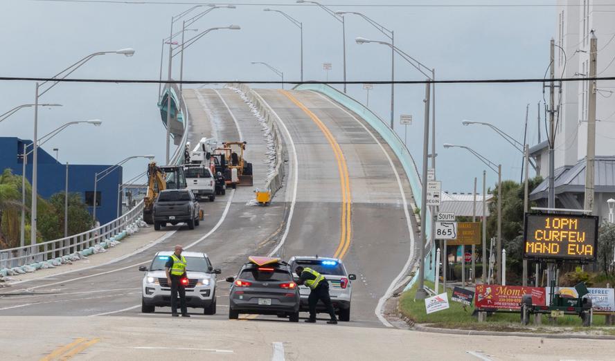
There are generally two levels of evacuation orders: voluntary and mandatory. A voluntary evacuation means conditions are potentially hazardous, and residents should consider leaving, particularly those with medical needs or in mobile homes. A mandatory evacuation means conditions are severely dangerous, and residents must leave. Ignoring a mandatory evacuation order is not only incredibly dangerous but also illegal in many areas, and first responders may not be able to assist you once conditions deteriorate.
Beach access is typically closed before, during, and after a hurricane. Before, closures allow for evacuation and prevent people from being stranded. During, closures protect people from the storm's immediate dangers. After, closures are necessary to assess damage, remove debris, and ensure roads are safe for travel. Expect closures to last for several days, or even weeks, depending on the storm's impact. It's vital to respect these closures and avoid attempting to access beaches until authorities have given the all-clear.
Coastal State Evacuation Zone Information – Hurricane Season 2026
| State | Official Evacuation Zone Map Link | Zone System Description |
|---|---|---|
| Florida | https://www.floridadisaster.org/know-your-zone/ | County-based evacuation zones (A-E) determined by storm surge risk and vulnerability. Some counties use alphabetical zones, while others use numerical. |
| Alabama | https://ema.alabama.gov/evacuation-zones/ | Five coastal counties utilize evacuation zones (1-5) based on proximity to the coastline and anticipated storm surge. |
| Mississippi | https://msema.org/hurricane-preparedness/evacuation-zones/ | Coastal counties are divided into zones based on potential storm surge inundation. Zones are generally numbered. |
| Louisiana | https://www.la-sheriffs.org/hurricane-evacuation-zones/ | Parishes along the coast utilize evacuation routes and zones, often categorized by risk level and proximity to water. |
| Texas | https://www.tdem.texas.gov/hurricane-evacuation-zones/ | Evacuation zones are determined by the Gulf Coast region and are categorized based on the level of threat from storm surge. |
| North Carolina | https://www.ncdps.gov/our-organization/emergency-management/hurricane-preparedness/evacuation-routes | Coastal counties use zones based on vulnerability to storm surge. Zones are designated A, B, or C, with A being the most vulnerable. |
| South Carolina | https://www.scemd.org/preparedness/evacuation/ | Evacuation zones are designated by county and are based on the potential for storm surge and flooding. |
Illustrative comparison based on the article research brief. Verify current pricing, limits, and product details in the official docs before relying on it.
Prepping your truck for the sand
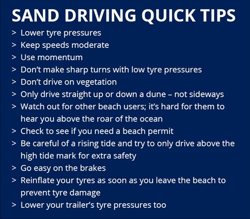
Preparing your vehicle for potential beach driving during an evacuation goes far beyond the standard advice of checking your oil and coolant. Tire pressure is critical. For sand driving, you'll generally want to reduce your tire pressure – around 15-20 psi is a good starting point for most vehicles, but this depends on tire size and load. Wetter sand requires lower pressure than dry sand. Experimenting before a real emergency is smart.
Don’t underestimate the importance of robust recovery points. A good tow strap and a couple of shackles are essential, but a winch is a game-changer if you get seriously stuck. Ensure these are properly rated for your vehicle’s weight. Consider the limitations of your 4x4 system. Some systems are better suited for sand than others, and all-wheel drive is not the same as four-wheel drive.
Before a potential storm, have a qualified mechanic inspect your vehicle. Pay particular attention to your battery, alternator, and starter, as saltwater exposure can quickly cause corrosion. Ensure your electrical system is sound, including headlights, taillights, and turn signals. A failing electrical system can leave you stranded, especially at night. Also, check your vehicle’s undercarriage for any existing damage that could be exacerbated by saltwater exposure.
Navigating Washed-Out Roads and Debris
Driving on beaches after a hurricane has passed is incredibly hazardous. Roads may be washed out, hidden beneath the sand, or compromised by erosion. Debris – trees, power lines, pieces of buildings – will be scattered everywhere. Slow speeds are paramount. You need time to react to unexpected obstacles. High visibility is also critical; use your headlights even during daylight hours.
Be extremely cautious when approaching standing water. It’s impossible to know what lies beneath the surface. Even a 4x4 vehicle can be swept away by currents or sink into unseen holes. Saltwater is incredibly corrosive. Thoroughly wash your vehicle’s undercarriage, engine compartment, and exterior as soon as possible after driving through saltwater or flooded areas.
Assess the stability of sand roads before attempting to drive on them. Look for signs of erosion or washouts. If the sand is unusually soft or unstable, it’s best to avoid it. Remember that storm surge can dramatically alter the beach landscape, creating new hazards you’re unfamiliar with.
Emergency Supplies for Beach Evacuations
A standard emergency kit is a good start, but a beach evacuation requires additional supplies. A portable air compressor is essential for reinflating your tires once you reach paved roads. Extra fuel is critical, as gas stations may be closed or have limited supplies. A shovel can be invaluable for digging your vehicle out if it gets stuck.
A comprehensive first-aid kit is a must, along with waterproof communication devices. A satellite messenger or a hand-held radio can be lifesavers if cell service is unavailable. Pack high-calorie, non-perishable food and plenty of water. Don’t forget essential medications.
Crucially, bring a physical map of the area. Cell service is often unreliable during and after a hurricane, rendering digital maps useless. A printed map can help you navigate alternative routes and locate essential resources.
- Portable air compressor
- Extra fuel (full jerry can)
- Shovel
- First-aid kit with trauma shears
- Waterproof communication devices (satellite messenger, hand-held radio)
- High-calorie, non-perishable food
- Physical map of the area
- Flashlight with extra batteries
- Work gloves
- Tow strap and shackles
Surge and rip currents
Storm surge is just the ocean being pushed inland by wind. It isn't a slow tide; it's a wall of water that ruins everything it touches. Most people think the wind is the killer, but the water usually gets you first. Check the National Weather Service maps for surge depth, not just the wind speed.
Never attempt to drive through floodwaters, even in a 4x4 vehicle. The depth of the water is difficult to judge, and even shallow water can damage your engine or sweep your vehicle away. Rip currents are powerful channels of water flowing away from the shore. They can quickly pull vehicles into the ocean, even if you're not directly in the water.
These forces are unpredictable and can change rapidly. Always err on the side of caution. If you encounter floodwaters or strong currents, turn around and find an alternate route. Don't underestimate the power of the ocean during and after a hurricane.
Legal Considerations and Local Ordinances
Beach driving regulations vary significantly by location. Some beaches require permits, while others have restrictions on vehicle types or hours of operation. Speed limits are typically lower on beaches than on paved roads. It's your responsibility to know the specific rules for the area you're in.
Violating beach driving regulations can result in fines, vehicle impoundment, or even criminal charges, especially during a state of emergency. Ignoring posted signs or disregarding the instructions of law enforcement can have serious consequences. Always check with local authorities for the most up-to-date information.
Resources for finding local ordinances include city and county websites, park ranger stations, and tourism offices. Don’t assume the rules are the same from one beach to another.


No comments yet. Be the first to share your thoughts!