
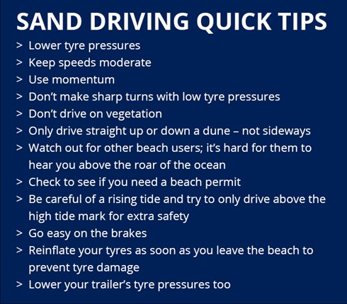
The reality of driving on sand
I remember one trip to Corolla, North Carolina, a few years back. We’d seen photos of the wild horses roaming the beaches and were determined to find them, driving our 4Runner along the coast. It quickly turned into a stressful situation. The sand was softer than expected, the tide was coming in, and we started to sink. No cell service, no idea how far we were from firm ground, just a sinking feeling – and a vehicle rapidly becoming stuck. That’s how beach driving used to be for many of us: a mix of careful planning, a bit of luck, and a healthy dose of local knowledge.
For decades, successfully navigating sand meant relying on experience, talking to seasoned beach drivers, and carefully observing conditions. It was often a trial-and-error process. You learned the hard way which areas held hidden soft spots, where the tide line really was, and how to read the sand itself. But that’s changing. Technology is finally catching up, offering tools that can take some of the guesswork – and the risk – out of beach driving.
We are moving toward a setup where AI and GPS act as a co-pilot. It doesn't replace the feel for the sand you get from years of driving, but it helps when the tide is moving fast or the tracks disappear.
Why standard GPS fails on the coast
Standard phone GPS is built for pavement. Once you hit the dunes, the lack of landmarks and specific beach data makes them unreliable. You won't find soft spots or tide-dependent access points on a basic road map.
Fortunately, specialized GPS systems and apps are emerging to address these limitations. These systems often utilize multiple satellite constellations – like GPS, GLONASS, Galileo, and BeiDou – to improve accuracy and redundancy. Some also incorporate correction services, such as Real-Time Kinematic (RTK) or Differential GPS (DGPS), which can achieve centimeter-level precision. This is a huge leap forward for precise navigation on shifting sands.
A critical feature of these specialized systems is the ability to download maps for offline use. Many beaches have limited or no cell service, rendering online map apps useless. Pre-downloaded maps ensure you have access to essential information even when you’re off the grid. Look for apps that allow you to download detailed beach maps, including marked access points and known hazard areas. Being prepared with offline maps is non-negotiable.
Mapping terrain with AI
This is where things get really interesting. Artificial intelligence is being used to analyze vast amounts of data – satellite imagery, aerial photos, and user-submitted reports – to create incredibly detailed maps of beach conditions. These maps go far beyond simply showing the shoreline; they can identify areas of soft sand, hidden obstacles like rocks and debris, changes in elevation, and even current tide levels.
The AI algorithms work by identifying patterns and anomalies in the data. For example, they can detect areas where the sand appears darker or more compacted, indicating firmer ground. They can also identify areas where vegetation is sparse, suggesting potential soft spots. This information is then overlaid onto a digital map, providing drivers with a visual representation of the terrain.
Some companies are going even further, using machine learning to predict changing conditions based on tidal data, recent weather patterns, and historical trends. Imagine an app that can tell you, with a reasonable degree of accuracy, whether a particular area of the beach will be passable in an hour. That’s the power of AI in action. It’s not just about showing you what is there, but about predicting what will be there.
These systems also rely on crowdsourced data. Users can submit reports about sand conditions, obstacles, and hazards, helping to keep the maps up-to-date and accurate. This collaborative approach allows the AI to learn and improve over time, becoming more reliable with each new piece of information.
- AI suggests routes based on how soft the sand is right now.
- You get alerts for hidden rocks or debris washed up by the tide.
- Real-time Updates: The system adapts to changing conditions, providing up-to-date information.
Automating tire pressure
Getting the right tire pressure is arguably the most important factor in successful sand driving. Too much pressure, and you’ll float on top of the sand, increasing the risk of getting stuck. Too little pressure, and you risk damaging your tires or even losing a bead. It’s a delicate balance, and one that varies depending on the sand conditions and your vehicle’s weight.
AI systems can integrate with your vehicle’s Tire Pressure Monitoring System (TPMS) to provide real-time recommendations. By analyzing data about sand firmness, vehicle load, and tire size, the AI can suggest the optimal tire pressure for the current conditions. This takes the guesswork out of the equation and helps you maximize traction.
Automatic adjustment isn't common yet, but some aftermarket kits let you drop PSI from the cab. Eventually, these will likely link directly to terrain sensors to handle the adjustment for you. Getting the pressure wrong is usually why people end up buried to the axle.
Navigating Regulations with Tech
Local rules are a headache. One beach requires a seasonal permit while the next one over closes entirely for bird nesting. Keeping track of which pass you need for which stretch of sand is often the hardest part of the trip.
Fortunately, apps are starting to integrate permit information, beach closures, and local regulations. These apps can store your permit details digitally, making it easy to prove compliance if challenged. They can also send you alerts about changes in regulations, ensuring you’re always up-to-date.
The potential for AI to streamline this process is significant. Imagine an app that can automatically verify your permit status or even alert you to temporary closures due to weather or environmental concerns. Coast Buddy provides comprehensive resources on beach driving rules and regulations, and integrating this type of information into a smart driving app would be a huge benefit for beachgoers.
Gear Up: Tech & Traditional Tools
While AI and GPS technology are transforming beach driving, they don’t replace the need for traditional gear. A well-equipped vehicle is still essential for a safe and enjoyable experience. This includes recovery boards, a shovel, a tow strap, a first-aid kit, and a portable air compressor.
The OuterBanks.com provides a great list of essential gear for 4x4 beach driving. AI can even help you determine which gear to bring. By analyzing predicted conditions, the app can recommend specific items. For example, if the AI predicts extremely soft sand, it might suggest bringing extra-large recovery boards or a winch.
Upgrading to 'smart' beach driving tech does come with a cost. Specialized GPS systems can range from a few hundred to several thousand dollars. Subscription fees for AI-powered apps can add another $50 to $200 per year. However, the peace of mind and the potential to avoid costly recoveries can easily justify the investment for serious beach drivers.
What is next for sand tech
Looking ahead, the possibilities for smart beach driving are endless. Fully autonomous beach driving is unlikely in the near future, due to safety and regulatory concerns. However, we can expect to see increasing integration between AI systems and vehicle systems, such as traction control and stability control.
More sophisticated AI algorithms will be able to predict changing conditions with even greater accuracy. Crowdsourced data will play an increasingly important role, as more drivers contribute to the collective knowledge base. This will lead to more reliable and accurate beach maps.
I believe the biggest impact of this technology will be in making beach driving accessible to a wider range of drivers. No longer will it be limited to experienced off-roaders. Anyone with a capable vehicle and a smart driving app will be able to explore the beaches with confidence.

No comments yet. Be the first to share your thoughts!