
How beach navigation changed
Driving on sand is unpredictable. For years, we got by on paper tide charts and local advice, but people still buried their axles when the tide came in faster than expected. It was mostly guesswork and luck.
Early GPS devices offered a glimmer of hope, but their limitations were significant. They lacked the detailed maps needed for off-road terrain and often struggled with accuracy in coastal environments. The real shift began with the proliferation of smartphones and the development of specialized apps. These initially relied on pre-downloaded maps, which quickly became outdated, and lacked real-time information about changing conditions.
However, those early apps were a starting point. They demonstrated the potential of mobile technology to improve beach driving safety and enjoyment. Today, we’re experiencing a full-blown revolution in beach navigation. Advances in GPS technology, coupled with sophisticated app features and community-driven data, are making beach driving smarter and safer than ever before. It’s a far cry from relying solely on a paper tide chart and hoping for the best.
The difference now isn't just having a map, it's having a map that understands the specific challenges of the beach environment. A map that adjusts for tides, learns from other drivers, and helps you avoid getting into trouble before it starts. That’s what the current wave of beach driving technology delivers.
GPS tech built for sand
Standard GPS signals can be unreliable in many beach environments. Trees, dunes, and even cliffs can obstruct the signal, reducing accuracy. That’s where advanced GPS technologies come into play. High-accuracy GPS systems, utilizing Wide Area Augmentation System (WAAS) or Satellite Based Augmentation System (SBAS), significantly improve positioning accuracy.
Differential GPS is particularly important for beach driving. It corrects for atmospheric errors that can distort GPS signals, providing a more precise location. This is crucial when navigating without distinct visual cues – imagine trying to pinpoint your location on a featureless stretch of sand. Even small errors can lead to getting off course or, worse, stranded.
Despite these improvements, GPS isn't perfect. Dense foliage near the beach or steep cliffs can still cause signal interference. App developers are working around this by incorporating dead reckoning – using sensors like accelerometers and gyroscopes to estimate position when GPS signals are weak or unavailable. This provides a more continuous and reliable navigation experience. The quality of these sensors varies between phones, so it’s something to consider.
App Features That Matter: What to Look For
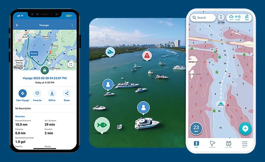
A good beach driving app goes far beyond simply displaying a map. Several key features can dramatically improve your safety and enjoyment. Integrated tide predictions are essential. Knowing the tide level in real-time, and being able to see predicted changes, is critical for avoiding getting your vehicle surrounded by water.
Real-time hazard reporting is a game-changer. This allows users to share information about obstacles like washed-out sections, deep ruts, or soft spots in the sand. Offline map availability is also vital, as cell service can be spotty in coastal areas. Being able to access maps and navigate even without a connection can be a lifesaver.
Vehicle-specific settings are a nice touch. Some apps allow you to input your vehicle type and tire size, and then provide tire pressure recommendations tailored to the sand conditions. Route recording and sharing is another valuable feature. You can save your favorite routes and share them with friends, or discover new routes from other drivers. It’s a great way to build a community and explore new areas.
I like the social side of these apps. Finding a quiet spot because someone else uploaded their track is better than following a generic map. It's reassuring to see a blue line on the screen where a truck similar to mine actually made it through.
- Live tide levels and 24-hour forecasts
- Hazard Reporting: User-submitted information on obstacles and conditions.
- Offline Maps: Access maps and navigate without cell service.
- Vehicle Settings: Tire pressure recommendations based on vehicle type.
- Route Recording/Sharing: Save and share routes with other drivers.
The best apps for 2026
The beach driving app landscape is constantly evolving, but several apps consistently stand out in 2026. Coast Buddy remains a top choice, known for its comprehensive coverage of beaches and its robust feature set. Coast Buddy’s strength lies in its detailed beach profiles, including information on permits, access points, and local regulations. It’s a solid all-around option, and the user interface is generally intuitive. Pricing is currently at $9.99/month or $99/year for premium features.
Sand Navigator takes a different approach, focusing heavily on real-time hazard reporting. Their community is incredibly active, and the app features a sophisticated verification system to ensure the accuracy of reports. It’s particularly strong in areas with frequent changing conditions. Sand Navigator is free to use, with an optional premium subscription ($4.99/month) that unlocks advanced features like offline maps and ad-free usage.
Tidal Tracks is a newer contender, but it’s quickly gaining popularity thanks to its innovative integration with tire pressure monitoring systems (TPMS). The app can automatically adjust tire pressure recommendations based on sand conditions and vehicle load, optimizing traction and preventing getting stuck. It’s also notable for its augmented reality features, which overlay tide lines and hazards onto your phone’s camera view. Tidal Tracks is available on a subscription basis: $14.99/month or $149/year.
Finally, BeachSafe prioritizes safety above all else. It's developed in partnership with several coastal rescue organizations and includes features like emergency SOS signaling and automated check-in/check-out notifications. While it lacks some of the more advanced features of other apps, it provides peace of mind for drivers venturing into remote areas. BeachSafe is a free app, supported by donations and partnerships.
Community-Powered Safety: Hazard Reporting in Action
The power of community-driven hazard reporting cannot be overstated. These systems typically allow users to report a variety of hazards, including soft sand, deep ruts, debris, washed-out sections, and even wildlife sightings. Reports often include photos and detailed descriptions, providing valuable context.
The best apps employ a verification system to ensure the accuracy of reports. This might involve requiring multiple users to confirm a hazard, or using algorithms to detect suspicious activity. A strong, active user community is essential for the success of any hazard reporting system. More users mean more reports, and more accurate information.
I've heard several stories of hazard reporting preventing accidents or even rescues. One user reported a large hole that had formed in the sand, which was later confirmed by other drivers. Another user reported a stranded vehicle, allowing rescuers to reach them quickly. These examples demonstrate the real-world impact of community-powered safety.
There’s increasing discussion about leveraging AI to automatically detect hazards from user data. For example, analyzing patterns of vehicle movement to identify areas where drivers are consistently slowing down or getting stuck. This is still in its early stages, but it has the potential to significantly enhance hazard reporting.
Tire Pressure & Tech: A Connected System
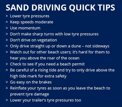
Proper tire pressure is arguably the most important factor in successful beach driving. Too much pressure, and you’ll float on top of the sand. Too little, and you risk damaging your tires or getting stuck. The ideal pressure depends on your vehicle type, tire size, and the sand conditions.
Apps are increasingly integrating with tire pressure monitoring systems (TPMS) to simplify this process. This allows the app to automatically read your current tire pressure and provide recommendations based on the terrain. Some apps even offer automated deflation/inflation systems, which can adjust tire pressure on the fly.
Connecting your tires to the app stops the guessing game. You aren't just dropping air until the tires look flat; you're hitting the exact PSI needed for the current heat and sand density. It saves the sidewalls and keeps you moving.
No comments yet. Be the first to share your thoughts!